
Search Delaware Streets by Address
Begin a Delaware street search with one specific address. The county’s address-first route is the Delaware County Auditor property search, followed by the official GIS view. Keep the parcel number once it appears. That identifier is more stable than a road string when a mailing style, map label, or historic source differs. A parcel record can show property facts and an owner field, but neither is a statement about a current occupant. The useful result is a documented address-and-parcel trail.
- Enter the complete address in the Auditor or GIS property search and retain the returned parcel identifier.
- Open the same location in Delaware County GIS and compare the Address Point, Parcel, and Street Centerline layers.
- Check the Zip Code, Municipality, and Annexation layers before describing the address as being within the City of Delaware.
- Use the parcel number, legal description, or recorded reference in the Delaware County Recorder search for land-instrument context.
- For historical address work, consult a dated DCHS street guide and then its alpha directory section. Keep the volume, page, and year with the note.
A named voter inquiry is separate from this street-by-street process. Ohio’s official voter lookup requires a first name, last name, and county, and it has no road or address browse. The voter file therefore cannot be used to turn a Delaware street directory into a road roster.
Delaware GIS Street Layers
The County’s official GIS map-layer inventory distinguishes several things that often get collapsed into one address. An Address Point marks an assigned location. A Street Centerline draws the road. A Parcel draws land boundaries. Building Outline represents a structure footprint. The same service also lists Zip Code, Township, Municipality, Annexation, Tax District, School District, Subdivision, Farm Lot, and PLSS layers. They are reference layers, not a survey or a current-person record.
The GIS program has announced a replacement viewer and cautions that new-viewer geometry can lag a recent change until refreshed. Record the display date for any map observation. If map geometry and a recorded document point in different directions, preserve the conflict and use recorded or survey material for a legal question.
Source layers can make a Delaware street directory more precise without making it personal. They show the relationship between the road, the address point, and the parcel. They should not be used to produce a sequence of private addresses or names along a road.
Note: A map display date matters because the County’s current GIS transition can temporarily leave new geometry behind recent changes.
Delaware Street Search Fields
The Auditor GIS viewer offers four distinct routes: Property, Advanced, Subdivision, and Intersection. One property-search term is required, while the intersection route helps locate a road crossing rather than select a parcel. The field set below comes from the County GIS help material, so it is more useful than a generic street-search instruction.
| GIS field or tab | Input available | Street-research use |
|---|---|---|
| Property | Owner Name, Address, Parcel Number, smart autocomplete | Find one property from a known address or parcel. |
| Advanced | Street Name, Municipality, Township, Subdivision, Property Type | Set geographic context before narrowing to a particular parcel. |
| Advanced details | Tax or School District, conveyance dates, year, beds, baths, area, acres, value | Property characteristics, not evidence of a person at the location. |
| Subdivision | Name, recorded dates, instrument, Book/Page/Cabinet/Slide | Reach plat and development context. |
| Intersection | Two road names | Navigate to a junction; it does not select a parcel. |
The viewer also supports point, polygon, box, and line selections plus TXT, CSV, and PDF exports. Those exports are research workpapers. A broad road-name result still needs a property-specific purpose and an official-source check.
Delaware Address Record Coverage
A Delaware street directory works by matching each question to its actual custodian. The parcel number links the Auditor, GIS, Treasurer, and Recorder more reliably than a street name alone. Recorded land instruments document transactions and party roles on a date. They do not prove present residence. Where an online result is incomplete, ask the office that keeps the record for the existing item, a date range, and the preferred format.
| Address-keyed source | What it can establish | Where to use it | Access boundary |
|---|---|---|---|
| Auditor property record | Parcel, address, value, characteristics, conveyance context | Delaware County Auditor | Current property data, subject to its disclaimer. |
| GIS layers | Parcel, address point, road, ZIP, municipality, annexation, subdivision | County GIS / Auditor | Public viewer; geometry may lag during transition. |
| Recorder land instruments | Deeds, mortgages, liens, land contracts, plats, legal descriptions | Delaware County Recorder | Generally online from 1990; pre-1990 needs office research, and some later records were not computerized. |
| Treasurer tax route | Parcel and tax-account pathway | Delaware County Treasurer | A tax mailing address is not proof of residence. |
| Historic street guides | Dated street and householder references | DCHS and DCDL collections | Historical evidence only, with volume and page citation. |
| Ohio voter lookup | Named registration and precinct context | Ohio Secretary of State / Board of Elections | First name, last name, and county required; no street browse. |
County offices at 145 N. Union Street include the Auditor, Recorder, and Treasurer. The Recorder can be reached at 740-833-2460, and the Auditor at 740-833-2900. The County’s public-records request route accepts email, phone, mail, in-person, verbal, or offered-form requests, but an office does not have to create a new record or research an undefined topic.
Note: Recorder online land-record coverage is generally 1990 forward, so an empty screen does not prove that an older instrument does not exist.
Delaware Parcel and Plat Context
Address research gains clarity when its terms stay separate. The recorder’s record types include plats and zoning resolutions as well as deeds and liens. Search by name, tract, book and page, or instrument number as the document supports. For older real-estate research, the online boundary is not the beginning of the record. The Recorder directs pre-1990 research to its office and notes that some documents after that point were never computerized.
- Parcel
- A County land-unit identifier that connects the Auditor, GIS, Treasurer, and Recorder routes.
- Situs address
- The physical property address used in a property record, which should remain distinct from a mailing address.
- Plat
- A recorded map or plan that provides land-development and subdivision context, not a household list.
- Historic street guide
- A dated directory section arranged by street and householder, useful only with its original year and page.
For a subdivision question, GIS can search subdivision name, recorded date range, instrument number, and older Book/Page/Cabinet/Slide references. The result may point toward a recorded plat PDF. That is land-development evidence, not a neighbor list.
Delaware Street Boundary Checks
Postal delivery, City geography, County parcel geography, and legal descriptions are different source categories. USPS lookup confirms delivery formatting for a specific address. County GIS supplies a Zip Code layer, plus Municipality and Annexation layers. A Delaware, OH 43015 mailing label therefore does not by itself resolve a City-limit question. For a location near a boundary, compare all three GIS layers and write down which category each one represents.
The City’s zoning-map notice adds a local warning: the official zoning map on file in Planning controls over its electronic representation. Planning and Community Development is the route for a targeted request by address, record type, and date range. No stable public City permit-result database was found in the research, so an address-specific request is the documented fallback rather than an assumed online search.
Broad planning labels such as Northwest, East Side/Old Colony, University District, Marvin/Delaware Meadows, West, and Southwest are community descriptions. They are not precise legal boundaries unless the cited planning document says so. Use the map layers rather than assigning a neighborhood label from a postal address.
Note: A ZIP label describes delivery geography, while Municipality and Annexation layers are the County’s visual sources for local jurisdiction.
Delaware Historic Street Guides
The Delaware County Historical Society collection in Ohio Memory is the strongest address-history layer for this street directory. The digitized city and county directory series includes 1859–60, 1880–81, 1890–92, 1893–94, 1897, 1899, 1901, 1905–06, 1908–09, 1915, and 1922. City pages and county taxpayer or residence sections must be distinguished before treating an entry as City evidence.
Several volumes provide a practical street-first route. The 1901 Street & Number Directory runs on pages 101–123. The 1905–06 Street Guide and Householders runs on pages 177–208, and the 1908–09 guide occupies pages 15–45 before the alpha directory. The 1922 Street Guide/Householders runs on pages 15–54. Find the date and street entry first, then use the alpha section of the same volume to cross-check it.
The Delaware County District Library Local History Room adds historical directories, atlases, Sanborn maps, census microfilm and indexes, yearbooks, church histories, and Delaware Gazette microfilm from 1821 to the present. That collection is appropriate for a dated address question. It is not evidence that an old entry describes the location today.
Note: Historic directory evidence needs a volume and page citation because a dated listing cannot confirm a present address.
Delaware Street Record History
Delaware was platted on May 9, 1808, on the west bank of the Olentangy River, and Delaware County’s documented operations began in 1808. Early street work should therefore rely on the original kind of evidence available for its era: a plat, map, directory, road record, or legal description. Modern street labels alone cannot settle an older address question. The County Records Center lists road records, commissioners records from 1808, and other historic series that can provide archival routing.
The 1859–60 directory is identified as the first issue in the DCHS digital collection. Its run through 1922 gives recurring City, street, and address evidence. The 1905–06 Baker’s volume is especially useful because it pairs an alpha directory on pages 17–146 with its Street Guide and Householders on pages 177–208. Date the evidence closely and do not turn a historic listing into a present-tense conclusion.
Research found no official City-wide compilation of every historic street-name change or renumbering. Where a historic number will not reconcile with the present parcel, mark the address continuity uncertain and compare a historic guide, historic atlas or Sanborn path, Recorder legal description, present GIS, and municipal annexation layer. Do not fill that gap with a guess.
Delaware Street Layer Reference
The County publishes its Delaware County Data map-service inventory as the official source for the layer names used in address research.
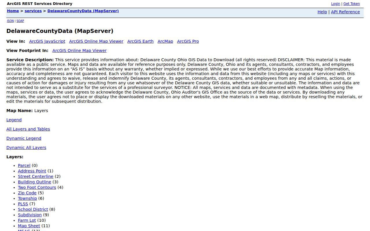
Seeing Parcel, Address Point, Street Centerline, Municipality, Annexation, and Zip Code as separate layers helps keep a Delaware street search tied to geography rather than a claim about people.
Delaware Street Research Limits
A street directory cannot show a current household roster. A recorded party, owner field, tax mailing address, or historic directory entry has its own date and scope. Ohio’s voter tools do not provide a road browse, and protected voter information is excluded under ORC 3503.13. Driver and motor-vehicle personal information is confidential except as statute permits. Court and vital materials also carry separate limits.
Ohio’s Public Records Act, ORC 149.43, allows inspection and copying of non-exempt records. It does not erase redactions or safety programs. Safe at Home protects qualifying survivors through address confidentiality. If a record suggests a protected address or a credible safety concern, suppress location-revealing detail and use the official custodian or Safe at Home route.
Lawful use. Use Delaware street records for a specific, lawful property or historical question. Do not use address information to target, stalk, harass, or harm another person.